
Costanera Sur Ecological Reserve: Plan Your Walk
Choose a short wetland walk or a longer river outing at Costanera Sur, with entrance advice, opening-hour checks and practical preparation.
Choose Costanera Sur for a nature walk that gives Buenos Aires a different scale: wetlands, birds and the Río de la Plata beyond Puerto Madero. Decide at the gate whether you want a short observation walk or a longer outing towards the river. The best route is the one that fits the open paths, the weather and your return time, rather than a loop copied from an old map.
Our Buenos Aires culture and neighbourhood guide helps choose the rest of your city visit. This guide addresses a narrower question: how to organise a manageable walk inside the ecological reserve, with enough time to notice the landscape instead of simply crossing it.
Fast facts
| Decision | Planning information |
|---|---|
| Location | East of Puerto Madero, beside the Río de la Plata |
| Admission | General entrance is free |
| Straightforward meeting point | South entrance, Avenida Tristán Achával Rodríguez 1550 |
| Usual visiting days | Tuesday–Sunday and holidays; verify exceptions and weather closures |
| Suggested allowance | 90 minutes–2 hours for a short visit; 3–4 hours for a slower river-focused outing |
| Essential preparation | Water, sun protection, suitable footwear and a confirmed return route |
The durations are editorial suggestions, not measured trail times. Practical sources were checked on 3 November 2026. Exact gate hours need reconfirmation: official material available online is inconsistent, as explained below. Do not make this an arrival-at-closing-time excursion.
Understand the reserve before choosing a route
Costanera Sur is protected habitat, not simply another landscaped park. The Argentine government's Ramsar description identifies wetland environments and records its designation on 22 March 2005. The value of the visit lies in observing how water, vegetation and animal life occupy land beside a dense urban district.
You do not need to be a specialist birdwatcher. Choose a place where you can stop without obstructing the path, watch movement across the water and listen before moving on. A bird disappearing into vegetation can tell you more about the habitat than a distant photograph taken while hurrying to the next viewpoint.
Decide what would make the outing worthwhile before entering. For some visitors that is a quiet hour by a lagoon; for others it is reaching a permitted river viewpoint. Those are different ambitions. Neither requires covering every trail, identifying a particular species or reproducing a photograph from another season.
Use a named entrance, not the centre of the green area
The south entrance at Avenida Tristán Achával Rodríguez 1550 is a practical fixed point for directions and meeting companions. The national tourism overview distinguishes the south access near Brasil and the Lola Mora fountain from the north access near Viamonte. Select an entrance before arranging a car or deciding where to meet.
A map pin in the reserve's interior is not an entrance. From the city centre, include the actual approach through or around Puerto Madero, and check the available crossings of the docks. A route that appears short in a straight line may involve a different pedestrian approach. Use current directions from your accommodation rather than choosing a transit line solely because an old guide lists it.
At the gate, ask which paths are open, where the nearest toilets are and when you must start returning. Photograph the current map or keep a copy accessible on your phone. Identify your exit before walking away; leaving through the other gate changes the journey back and any planned pickup.
Resolve the opening-hours uncertainty first
The city's reserve page currently redirects to its historical section. It publishes Tuesday–Sunday and holiday access, with 08:00–18:00 for April–October and 08:00–19:00 for November–March. Other official city material has listed 09:00–18:00. These online schedules should not be treated as a verified live operating notice.
Confirm the day's opening, last admission and exit time through the reserve's current official information or staff before travelling. A mid-morning start with a generous return margin is a more resilient plan than relying on the earliest advertised opening or the latest summer closing. It does not remove the need to check closures.
Rain, strong winds and weather alerts can interrupt access; paths may remain affected after rain stops. A clear sky outside your hotel is not evidence that the reserve has reopened. If the gate is closed, do not try another unmarked access or treat a fence as a route-finding problem. Switch to a city activity and save the reserve for a suitable day.
Option one: a short walk with time to observe
Use the Laguna de los Coipos as your short-walk anchor. The city's Paseo de los Coipos notice describes the lagoon boardwalk and observation spaces opened in 2023. Ask which sections are usable today; the opening announcement is not a live access report. For a longer lagoon-side option, locate Sendero de los Lagartos, between Coipos and the Patos/Gaviotas wetlands, on the entrance map.
Budget roughly 90 minutes–2 hours inside as an editorial allowance. Spend part of that time standing still, reading interpretation and watching the edges of the water. A short route with several pauses often offers a stronger sense of the reserve than a longer circuit completed at exercise pace.
Set a turnaround time before leaving the entrance. If you find something interesting, use the remaining time there instead of extending the route automatically. This approach works particularly well for a group whose walking speeds differ: the shared activity is observation, not reaching a distant marker together.
Option two: make the river the main destination
For the river option, use the city's official tourism map and route guide, printed pages 10–13, to recognise Sendero de los Lagartos, Sendero del Medio towards the river and Sendero de los Plumerillos for the described return. These names help you discuss a precise route with staff. The guide is an orientation reference, not proof that every connecting section is open today.
Allow about 3–4 hours inside, including pauses, as an editorial planning estimate. This is not a promised walking duration or a stated trail distance. Adjust it to the route recommended at the gate and the slowest walker in your group. Keep enough time for the return before adding any optional branch.
The river edge is for observing the landscape from permitted areas, not for swimming. The city's visitor precautions explicitly prohibit entering the Río de la Plata. An open view of water does not establish safe bathing, and a patch of shore should not be treated as a city beach.
Walking, cycling and access needs
Walking makes it easier to stop for birds and small changes in vegetation. Cycling changes the rhythm: you cover ground faster but need to manage other visitors and stopping points. Ask whether bicycles are allowed on that day's open paths before committing to a rental. No rental availability or price is assumed here.
If your main aim is wildlife observation, choose walking unless a bicycle solves a specific distance or mobility need. Do not turn narrow shared paths into a speed route. Dismount where required and keep any stop clear of the passage used by other visitors.
For wheelchairs, mobility aids or pushchairs, confirm the surface, gradients, accessible toilets and usable route directly. A flat-looking green area on a city map does not establish that every path is manageable after rain. Ask about a shorter suitable section rather than relying on the accessibility of the entrance alone.
The official activity directory includes guided visits and inclusive activities. Check current dates, registration and meeting points separately. A programme description is not evidence that a guide will be available when you arrive without booking.
Pack for a wetland walk rather than a café circuit
Bring drinking water before entering. The reserve's precautions warn that water is not available along its routes; do not build your plan around finding a refill halfway through. Carry sun protection, insect repellent suitable for your needs and footwear that can handle the day's surfaces. Keep the bag light enough that you can carry it comfortably for the whole return.
Have a simple food plan before setting out. A meal in Puerto Madero before or after the reserve is easier to organise than assuming food will be available beside the path you choose. If you bring a snack, use permitted stopping areas and take all packaging out or use the appropriate bins. Do not feed animals, even when they approach people.
Observe from the paths and respect barriers. Avoid playing recorded bird calls to draw wildlife closer or moving into vegetation for a clearer photograph. The point is to see the place functioning as habitat, not to arrange an encounter for the camera. Carry binoculars if you already use them; patience is more useful than buying equipment solely for a short visit.
Fit the reserve into one realistic city day
Keep the reserve as the main outdoor commitment for that part of the day. Puerto Madero is a natural place for a subsequent meal or a shorter urban walk, but the dockside promenade and the protected reserve are separate experiences. Walking around the docks does not mean you have entered the habitat beyond them.
Do not place a fixed tour or airport transfer immediately after your estimated exit. Leave space to shorten the walk, rest and travel onward without rushing. If the weather removes the reserve from your plans, our free things to do in Buenos Aires guide provides alternatives to consider according to that day's opening information.
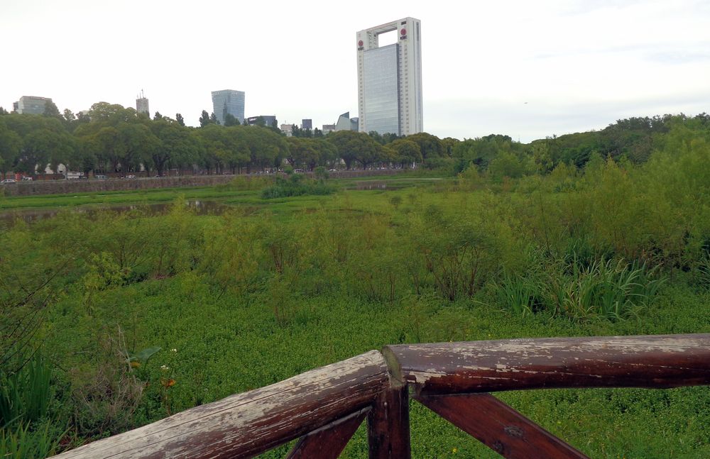
Cover photograph: Laguna de los Coipos vegetation seen from an observation railing in Costanera Sur — Archive photograph; no edits to the downloaded file — Roberto Fiadone, CC BY-SA 4.0.
Frequently Asked Questions
Is Costanera Sur free to enter?
General admission is free. Transport, food and any separately arranged services are different expenses; guided activities may require registration even when free.
What are the current opening hours?
Official online material is inconsistent: the historical reserve page gives seasonal 08:00 openings, while other city material lists 09:00–18:00. Confirm the current day's gate and exit times before leaving, including weather closures.
Can I swim in the Río de la Plata from the reserve?
No. The city explicitly prohibits entering the river from the reserve. Enjoy the view from permitted areas and follow signs and staff instructions.
Is a short visit worthwhile?
Yes, if you select an open route near your entrance and leave time for observation. Around 90 minutes–2 hours is an editorial allowance for a short visit, not a guarantee of reaching the river.


Keep Exploring
Royal Botanic Gardens Melbourne: Plan Your Walk
Choose a relaxed lakeside visit or a plant-focused walk at Royal Botanic Gardens Melbourne. Includes free entry, guided experiences, accessibility and the distinction from Cranbourne.
Bondi to Coogee: Plan Your Coastal Walk
Choose a full coastal outing or a shorter section between Bondi, Tamarama, Bronte and Coogee, accounting for closures, steps and your return journey.
Brooklyn Bridge and DUMBO: Plan Your Walk
Cross toward the skyline or finish beside the river: choose your Brooklyn Bridge entrance, DUMBO stops and return journey before setting out.