
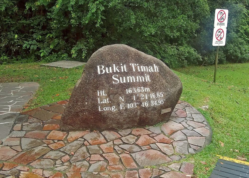
Bukit Timah Nature Reserve: Choose Your Forest Walk
Choose a Bukit Timah route with official distances, summit access, Hindhede alternatives, opening hours and practical advice for the forest.
Choose Bukit Timah Nature Reserve for a forest climb, not a skyline viewpoint. The direct summit route gives a clear objective without requiring a long cross-island hike. If your group wants a gentler outing, nearby Hindhede Nature Park is a more suitable starting choice than committing everyone to the hill.
Bukit Timah sits among Singapore's urban districts but remains a protected forest landscape. Its appeal is the change from roads and buildings to trees, roots, birds and a sustained uphill effort. Use our Singapore highlights guide to decide whether this active morning belongs in your stay. A walk here should replace another substantial outing, rather than become a hurried extra before lunch across the city.
Visitor information checked on 17 November 2026. Route lengths below are NParks' published route lengths, not interchangeable return distances. Suggested time allowances are editorial estimates; trail signs and current closures take precedence.
Fast facts
| Detail | Planning information |
|---|---|
| Main access | End of Hindhede Drive, near the visitor centre |
| Nearby MRT | Beauty World |
| Reserve hours | Daily 07:00–19:00 |
| Walking admission | Free; transport and parking are separate |
| Summit | Bukit Timah Hill, 163 m |
| Direct route | Route 1, listed as 1.2 km and moderate |
| Gentler nearby option | Hindhede Nature Park and its quarry viewpoint |
| Suggested allowance | About 2–3 hours for a measured summit outing, including approach and breaks |
NParks' reserve visitor information gives the access point, hours and accessibility limits. An accessible visitor-centre area does not mean that the summit trails are wheelchair accessible.
Choose the route before leaving the visitor centre
The official hiking guide lists four routes beginning at the visitor centre. Only routes 1, 3 and 4 lead to the summit. This is the first decision to make: do you want a direct climb, a more demanding forest route or a shorter outing without the summit?
| Route | NParks length and difficulty | Main purpose |
|---|---|---|
| 1 | 1.2 km, moderate | Direct approach to the summit by the main road |
| 2 | 0.8 km, moderate | Telecomm Tower route; not a summit route |
| 3 | 1.8 km, difficult | Summit via South View Path and Cave Path |
| 4 | 3 km, difficult | Summit route with an additional Dairy Farm loop |
These numbers describe the named routes. Consult the map for the direction, start, finish and return you intend to walk; do not assume that the shortest number is your complete outing from the MRT station. Reaching the hill, stopping and returning to transport add time even when the route itself appears compact.
Route 1 is the clearest introductory choice when the summit is your aim. Routes 3 and 4 are options for people who deliberately want harder walking, not automatic upgrades. Choose according to the slowest walker in your group and the day's conditions, rather than the fitness of the person holding the map.
What the summit does and does not offer
At 163 m, Bukit Timah is Singapore's highest natural point. That number describes elevation above sea level, not how much ascent every route requires. Do not use it as a calculation of the climb or as proof that the walk must be easy. Heat, humidity and a sustained slope can make a short distance feel substantial.
The summit is a forest destination. Choose the outing for the climb and the surrounding vegetation rather than expecting an open observation deck over Marina Bay. The summit marker offers a clear finishing point for the uphill section, but leave space for others and avoid turning it into a prolonged photography session when people are waiting.
Plan the descent as part of the walk. Getting to the marker is not the same as completing the excursion. A tired group still needs to return through the reserve and reach its onward transport. Carry enough water for that remaining section and leave the next appointment flexible enough to descend without rushing.
Getting there: use the reserve entrance, not a district name
Set your destination to the Bukit Timah Nature Reserve visitor-centre area at the end of Hindhede Drive. “Bukit Timah” also refers to a wider urban area, so a generic district pin is not sufficient. NParks identifies Beauty World MRT as the nearby station; check the walking approach from your chosen exit in a current route planner.
If you arrive by taxi, identify the public access point rather than asking to be taken to the summit. A car cannot replace the forest walk. For drivers, the official page lists parking near the visitor centre and says charges apply. Do not infer availability from the stated number of spaces, particularly when arriving later in the morning.
Save the reserve map before leaving reliable reception. At the entrance, compare your intended route with the displayed signs and any barriers. If a path is closed, choose an open route or shorten the visit; an old downloaded line is not permission to continue through a closure.
Make the forest the main attraction
Bukit Timah protects a remaining patch of primary rainforest, and its importance is larger than the summit photograph. Slow down on a safe, wider section and look at the structure around you: trunks rising above lower vegetation, buttressed bases, fallen leaves and changes in light under the canopy. You do not need to identify every species to notice these differences.
The reserve's official information highlights wildlife such as the greater racket-tailed drongo and Malayan colugo. Treat these as examples of the habitat, not a promised sighting list. Animals may be hidden, inactive or elsewhere; a quiet walk without a recognisable mammal is still a forest visit.
Keep to marked paths and leave plants, seeds and other natural material where they are. Moving off the trail for a photograph damages the very setting you came to see and can take you towards unsafe ground. Use a zoom rather than closing the distance to wildlife. Conversation at a moderate volume also makes it easier for your group to hear birds and approaching walkers.
Hindhede is a useful alternative, not a consolation prize
The adjacent Hindhede Nature Park has easier walking trails and a viewpoint over Hindhede Quarry. NParks lists the same 07:00–19:00 opening hours and describes wheelchair access via the ramp in front of the Bukit Timah Nature Reserve Visitor Centre. Confirm any specific access need before travelling.
Choose Hindhede first when the group includes someone who would not enjoy a sustained climb, when you mainly want a short nature stop or when energy is uncertain after a long flight. Quarry scenery and forest-edge observation give the outing a coherent purpose without making the summit compulsory. Allow roughly 45–90 minutes as a flexible editorial suggestion, adjusted to the route and pauses you choose.
It can also follow a summit walk if everyone still feels comfortable, but it should not be treated as an automatic extension. Decide after returning towards the entrance, when you can assess energy honestly. If you want a separate reservoir walk on another day, compare our MacRitchie walking guide; its routes and TreeTop Walk rules belong to a different outing.
Weather, footwear and a sensible turning point
Choose a morning with enough daylight and a forecast that supports an outdoor walk. Earlier does not mean entering before the reserve opens. The 07:00–19:00 hours are the outer limit, not a suggestion to begin a demanding route close to closing. Leave time to return before access ends.
Wear shoes with dependable grip, carry drinking water and protect your phone from rain. A small backpack keeps hands available on uneven sections. Bring insect repellent if you use it and avoid carrying more equipment than the walk requires. There is no advantage in taking a heavy camera kit if it makes the descent uncomfortable.
If thunder, heavy rain or an official warning affects the outing, postpone or follow the instructions on site. A forest canopy is not a weather guarantee. Wet surfaces and fatigue are also reasons to turn around or choose a shorter route even without a formal closure. Agree that decision before starting, so returning early does not become an argument halfway up the hill.
Access needs, children and reserve rules
The reserve page limits wheelchair accessibility to the surroundings of the exhibition halls and toilet blocks. Do not describe the hill as step-free because its entrance has accessible facilities. Discuss the actual intended route with NParks if you need assistance, and consider Hindhede's published accessible approach as a separate option.
For children, decide based on walking experience and willingness to climb rather than age alone. Keep the group together, pause before everyone becomes exhausted and avoid promising a specific animal at the summit. If a pushchair is essential, choose an appropriate accessible outing instead of assuming it can follow every nature trail.
Pets are not permitted in the reserve or Hindhede. NParks also requires a permit application at least one month in advance for organised group activities involving more than 30 people. These conditions differ from the ordinary individual walk. Mountain-biking routes are another activity with their own rules; a line on the wider map is not automatically a pedestrian shortcut.
What to skip after the walk
Avoid turning a successful short forest morning into an unplanned expedition through every neighbouring park. Dairy Farm, Rifle Range and the Rail Corridor have their own access points, distances and notices. Connecting them should be a separate route-planning decision, not a spontaneous attempt to use every name visible on the map.
Give yourself time for a meal and a change of clothes if needed before returning to city sightseeing. Free admission does not make an outing costless in effort or travel time. The best version of Bukit Timah ends with enough energy to enjoy the rest of the day, whether you reached the summit or chose Hindhede instead.
Cover photograph: Bukit Timah summit marker surrounded by forest in Singapore, photographed in 2023 — Daniel Case, CC BY-SA 4.0.
Frequently Asked Questions
Is Bukit Timah Nature Reserve free to visit?
NParks lists the hiking and nature walks as free of charge. Transport and parking are separate, and organised programmes can have their own prices or booking conditions.
Which route is the simplest way to the summit?
NParks lists Route 1 as the direct main-road route, 1.2 km and moderate. Check the map for your complete outward and return plan; that figure is not automatically the total distance from the MRT station.
Is the summit suitable for wheelchairs?
The reserve's stated wheelchair accessibility covers the exhibition-hall and toilet-block surroundings, not the summit trails. Nearby Hindhede Nature Park has a published ramp access and may be a more appropriate option.
Is the TreeTop Walk at Bukit Timah?
No. The TreeTop Walk belongs to the Central Catchment/MacRitchie outing and has separate access routes and opening rules. Bukit Timah offers a different forest climb centred on its hill and summit.


Keep Exploring
Labrador Nature Reserve: Coast Walk and Closures
Plan a Labrador coastal walk around the Berlayar Creek closure, with maritime landmarks, reserve hours and practical access choices.
MacRitchie Reservoir: Choose Your Forest Walk
Choose a short reservoir walk or the longer TreeTop Walk, with verified distances, access points, bridge hours and practical planning.
Philosopher’s Path Kyoto: Choose Your Walk
Choose a canal-only walk or add Ginkaku-ji and Nanzen-ji, with clear endpoints, transport connections and realistic seasonal expectations.