
Sungei Buloh Wetland Reserve: Plan Your Visit
Choose Sungei Buloh trails and entrances, with birdwatching seasons, bus connections, tide closures and a realistic first-visit plan.
Choose Sungei Buloh for a slow wetland walk: birds feeding around tidal ponds, mangrove roots and coastal observation points. For a first visit, pick either the Migratory Bird Trail or a shorter coastal-and-forest outing, then add another section only if conditions and your energy allow. The reserve is in Singapore’s northwest; reaching it and returning to the city deserve their own space in the day.
This is a wildlife habitat, so the rewarding part is often waiting rather than covering distance. A quiet interval at a hide can be more useful than reaching every lookout. For the broader choice between nature, neighbourhoods and museums, use our Singapore attractions guide. Here the decision is which part of Sungei Buloh suits your interests and how to organise the outing.
Choose your focus before your entrance
| Your priority | Start your planning with | Practical implication |
|---|---|---|
| Migratory shorebirds | Migratory Bird Trail and tidal ponds | Keep time for hides and repeated observation |
| Mangrove plants and small animals | Mangrove Boardwalk | Look down at roots and mud, not only across the water |
| Coastal scenery and mixed habitats | Coastal Trail | Identify your return or pickup point before walking onward |
| A shorter family visit | Visitor Centre area, Junior Wetland and a selected short trail | Keep the route adjustable and supervise children |
| Photography | One habitat and a patient observation stop | Bring reach rather than trying to approach animals |
The current NParks reserve page lists 07:00–19:00, last entry 18:30. Self-guided walks are free. Treat two to three hours on site as an editorial allowance for an introductory visit, with transport additional; a dedicated birdwatcher may want substantially longer. Last entry is a gate limit, not a sensible arrival target for a substantial walk.
Understand the two centres
The Visitor Centre at 60 Kranji Way and the Wetland Centre are different arrival points. NParks lists parking at both. Search the actual centre name when arranging transport, and check the current park map against your chosen trail. A reservation or meeting message that says only “Sungei Buloh” is less useful than a named entrance and pickup point.
For a bird-focused outing, locate the tidal ponds, their observation hides and the Wetland Centre on the map before departing. For coastal scenery and the shorter forest options, orient yourself around the Visitor Centre side. The centres are part of the same reserve, but they are not interchangeable labels for one doorway.
If a driver drops you at one centre, decide whether you will return there or leave from the other. Save the pickup location on your phone while you still have time to check it. This avoids finishing a walk at an unfamiliar gate with a driver expecting you elsewhere. Travellers who need a short approach should settle this detail before leaving the hotel.
Getting there from Kranji
NParks currently directs public-transport visitors from Kranji MRT to bus 925 on Mondays–Saturdays, or 925M on Sundays and public holidays. Check the actual boarding stop, direction, alighting stop and remaining walk for your selected centre in a current journey planner. The service distinction matters: a Sunday plan copied into a weekday visit can lead to a different approach.
Build the return journey at the same time as the outward one. Save the return stop and check service availability for the time you intend to leave. A taxi or booked car can simplify the connection, particularly with children or bulky equipment, but no fixed fare or collection time is assumed here. Request the trip when you are at an identifiable, permitted collection point.
Do not attach a tightly timed city lunch immediately after your proposed trail finish. Wildlife stops, weather and the connection back all introduce uncertainty. Bring enough drinking water for the visit and arrange meals around the travel day instead of depending on an unverified café opening inside the reserve.
A first route for birds
The NParks walking guide lists the Migratory Bird Trail at 1.95 km. Use it as a habitat visit rather than a distance challenge. Begin with the current map and any closure notices, then give the first available hide several quiet minutes before deciding whether to move on.
At a hide, scan the whole scene first. Look for movement along the waterline, then examine one smaller area with binoculars. Watching how birds feed can be easier than identifying every species immediately. Note the shape of the bill, leg length and feeding behaviour; those observations make an identification guide more useful later.
The reserve’s birdwatching page identifies August–April as the migratory period and explains the role of the mudflats as feeding and resting habitat. Resident birds can be seen year-round. November therefore falls within the advertised migration window, but the date alone cannot promise a particular species or a busy hide.
Tides change the scene. An exposed feeding area and the same place under water provide different opportunities, so avoid interpreting one quiet viewpoint as evidence that the entire reserve has nothing to see. Ask staff which open areas are currently rewarding. The sensible response may be another hide or simply more waiting, rather than a longer circuit.
A first route for mangroves and coastal views
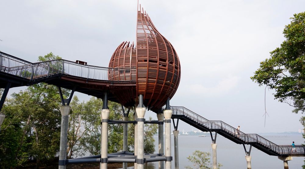
If your group is more interested in landscape and small discoveries than bird identification, choose the coastal side. NParks lists the Coastal Trail at 1.3 km, with viewpoints including Eagle Point and Kingfisher Pod. Its published short forest options include the Forest Trail and Mid-canopy Walk. Check their positions on the map before combining them; separate advertised trail lengths do not include every connecting walk.
Make one observation stop your focus. At a coastal viewpoint, compare the open water with the sheltered mangrove edge. On a boardwalk, pause where you can look at the roots and exposed mud without blocking other visitors. Mudskippers, crabs or a monitor lizard are possibilities, not items an itinerary can guarantee.
The operator’s Mangrove Boardwalk listing gives two distance options, so confirm the exact section on the current map rather than treating the longer figure as the length of one short boardwalk. You can enjoy a concentrated introduction to mangroves without turning the visit into a complete circuit of the reserve.
For families, Junior Wetland provides another possible focus near the Visitor Centre. Give children a simple observation task: find two different leaf shapes, notice an animal moving between water and land, or listen for different calls. This turns pauses into part of the outing. The site requires adult supervision for children under 13; water edges and steps deserve attention regardless of age.
Weather and high tides can change the route
Before travelling, read the notices linked from the main reserve page. NParks warns that some areas can close because of high tides or bad weather. A reserve opening time does not mean that every section is accessible throughout that day. A marked closure is a reason to change the walk, even if a map still shows the path.
For thunderstorms, follow the operator’s advice to avoid entering in bad weather and seek the nearest shelter if conditions deteriorate. A small umbrella is not a reason to continue across an exposed section. Check the forecast before departure, carry rain protection for your belongings and keep an indoor alternative in mind if the weather makes the outing unsuitable.
Footwear should handle wet surfaces, and a hat, drinking water and insect protection make a slow visit more comfortable. Carry what you can comfortably manage while standing still. A very heavy camera bag may become more limiting than the walking distance suggests.
Wildlife, photographs and accessibility
Sungei Buloh has wild animals, including estuarine crocodiles. Stay on designated trails, keep your distance and follow posted advice. Do not approach, feed or provoke wildlife; back away calmly when necessary. A photograph taken from farther away is preferable to moving toward an animal or the water’s edge for a clearer frame.
NParks prohibits pets, jogging, cycling, skating, scooters and drones within the reserve. Bicycle racks at an entrance do not imply that cycling the trails is allowed. Keep voices low around hides and leave room for other people to observe. A phone can record the landscape, while binoculars often add more to the wildlife experience than a larger camera.
The reserve is listed as wheelchair accessible, but that broad label does not confirm every trail, viewpoint or temporary diversion. Contact NParks about the specific entrance, route surface, gradients, toilets and turning points you need. Avoid making the Aerie Tower or a stepped feature essential to an accessible itinerary. The useful question is whether your selected route works, not whether the whole reserve carries one accessibility symbol.
Guided walk or independent visit?
NParks offers guided walks with advance registration; rain can cancel them. Check the event listing for the exact date, language, meeting place and availability rather than assuming that arriving on a weekend secures a place. A guided walk is particularly useful when the plants and smaller animals interest you but you do not yet know what to look for.
An independent visit gives you freedom to stay at one hide or shorten the route. Bring the map and choose a manageable main section. If you are comparing nature days, our Pulau Ubin guide covers a separate island outing with boat logistics and different walking or cycling choices. Treat that as an alternative day, not a nearby extension of Sungei Buloh.
Visitor information checked on 12 November 2026. Route combinations and visit allowances are editorial suggestions, not a personally timed itinerary. Check NParks notices and transport details again before departure.
Cover photograph: Kingfisher Pod and raised coastal walkway at Sungei Buloh Wetland Reserve — Archive photograph; no edits to the downloaded file — Scott Smith, CC BY-SA 2.0.
Frequently Asked Questions
How much time should I allow at Sungei Buloh?
Allow two to three hours on site for an introductory walk, plus transport. Birdwatchers who want to wait at several hides may prefer longer. Choose the main trail before adding other sections.
Which entrance should I use?
Choose between the Visitor Centre and Wetland Centre after locating your preferred trail on the current map. Coastal and short forest options and the tidal-pond birdwatching area lead to different arrival decisions.
Is Sungei Buloh worth visiting outside migration season?
Yes, if mangroves, resident birds and wetland landscapes interest you. The August–April migration window adds possibilities, but wildlife sightings are never guaranteed in any month.
Can I cycle through the reserve?
No. NParks prohibits cycling inside the reserve, although bicycle racks are available at the centres. Plan to explore the permitted trails on foot or confirm a suitable accessible route with the operator.


Keep Exploring
Night Safari Singapore: Plan Your Evening Visit
Plan a Night Safari evening around the tram, walking trails and presentation bookings, with current exhibit restrictions and a realistic return journey.
New York Botanical Garden: Plan Your Visit
Choose NYBG tickets, a forest or exhibition route, and the right Bronx arrival, with current tram limits and the 2026 Holiday Train Show dates.
Santa María del Tule: Plan Your Oaxaca Visit
Plan a thoughtful Tule tree visit, with botanical context, honest access checks, the BinniBus route to investigate and a Teotitlán pairing.