Explore the Dolomites on foot: a practical guide to the region’s best day hikes, from Tre Cime and Seceda to Lago di Sorapis, with route details, logistics, and local tips.
Best Day Hikes in the Dolomites
The Dolomites—UNESCO-listed, jagged limestone giants rising from green valleys—are one of Europe’s most photogenic mountain ranges. Their dramatic ridgelines, emerald alpine lakes and network of rifugi (mountain huts) make them ideal for unforgettable day hikes. This guide picks the top day walks across the Dolomites, with clear route details, difficulty ratings, practical logistics and local tips so you can plan a safe, scenic day on the trails.
Quick planning essentials
Before we dive into the routes, here are a few essentials to maximize enjoyment and safety on Dolomites hikes:
- Best season: Late June through September for most trails (snow can linger at higher elevations before July). Shoulder seasons offer fewer crowds but variable weather.
- Weather: Mountain weather changes fast. Check forecasts (MeteoBlue, local alpine forecasts) and start early to avoid afternoon storms.
- Maps & apps: Use Offline maps on Komoot, Outdooractive or Gaia; carry a paper map for backup.
- Gear: Sturdy hiking shoes, layered clothing, rain shell, sun protection, water (1–2 L), snacks, headlamp, basic first-aid, pole(s) for steep descents.
- Rifugi: Many trails include rifugi for coffee or lunch—great for shelter and local food.
- Safety: Some routes include exposed sections or via ferrata; if you plan to use via ferrata routes, hire a guide or bring proper kit. Emergency number in Italy: 112.
- Etiquette: Stick to marked trails, respect private pastures, and follow ‘Leave No Trace’ principles.
Top day hikes (by region)
1) Tre Cime di Lavaredo Loop (Three Peaks)
- Location: Sexten / Auronzo area
- Distance & time: ~10–12 km loop, 3–4 hours
- Elevation: ~400–500 m total ascent
- Difficulty: Easy–Moderate (stony trails, some exposed viewpoints)
Why go: Tre Cime are the Dolomites’ signature icons—three soaring faces visible from the classic loop. Sunrise and late afternoon deliver the best light (and fewer people).
Route notes:
- Start at Rifugio Auronzo (road access; parking fee). The paved road to Rifugio Auronzo is usually open in season—if you prefer lower crowds, take the early bus or hike from the valley.
- Follow trail 101/102 for the classic clockwise loop, stopping at Rifugio Lavaredo and Rifugio Locatelli for views and refreshments.
- Optional: Short detours to viewpoint platforms and the Croda dei Toni.
Local tip: Arrive early (before 9:00) if driving—parking fills fast. If you want a longer day, add the loop to Forcella Lavaredo and the Cadini di Misurina ridge.
2) Seceda / Odle Ridge (Alpe di Siusi outlook)
- Location: Val Gardena / Ortisei
- Distance & time: Variable—classic ridge out-and-back ~8–12 km, 3–5 hours
- Elevation: up to 800 m depending on start point
- Difficulty: Moderate (steep sections, high reward panoramas)
Why go: The Seceda ridgeline is famed for its serrated skyline and sweeping views over the Alpe di Siusi (Seiser Alm), perfect for dramatic photos.
Route notes:
- Most hikers take the Ortisei–Seceda cable car to save time and elevation; from the top station follow the ridge trail toward Pieralongia and the Seceda viewpoint.
- For a longer hike, descend to the Alpe di Siusi meadow and loop back through high pastures.
- In autumn, grazing cows and yellowed larches add gorgeous color.
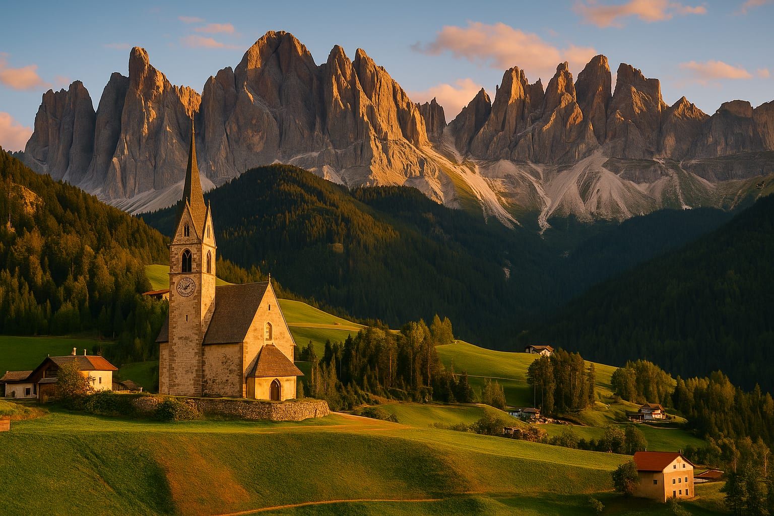
Local tip: Combine Seceda with a visit to nearby Val di Funes (Odle/Geisler peaks) for the Adolf Munkel Trail—one of the most scenic walks in the region.
3) Lago di Sorapis
- Location: Cortina d’Ampezzo area
- Distance & time: ~10 km round-trip, 3–4 hours
- Elevation: ~350–450 m gain, single narrow trail sections
- Difficulty: Moderate (narrow trail, rocky sections)
Why go: A turquoise alpine lake tucked beneath sheer walls—Sorapis appears surreal and is a perfect reward after a steep climb.
Route notes:
- Park at Passo Tre Croci or take local transport to the trailhead. Follow trail signs toward Rifugio Vandelli / Lago di Sorapis.
- The trail passes through forest and rocky slopes; a steep scree descent into the lake basin is required.
- Avoid midday or late-afternoon thunderstorms—the bowl is exposed.
Local tip: The lake is sensitive—don’t swim and take all litter home. Peak season brings crowds; start early for calm water and better photos.
4) Lago di Braies (Pragser Wildsee) & Croda del Becco options
- Location: Braies / Prags / Pragser Tal
- Distance & time: Lake loop ~3.5 km (1–1.5 hours); longer hikes to surrounding trails add 3–6 hours
- Elevation: Minimal on the lake loop; more for Alpine routes
- Difficulty: Easy to Moderate
Why go: Lago di Braies is postcard-perfect—emerald water framed by steep cliffs. The lake loop is accessible to most, while nearby trails lead to quieter viewpoints.
Route notes:
- The short lakeside circuit is stroller-friendly but can be crowded. For solitude, take the trail up toward Croda del Becco (Seekofel) or the Fanes plateau.
- There’s a popular rifugio by the lake; consider booking a table in high season.
Local tip: Parking is limited; use shuttle buses from Braies village or nearby towns. Sunrise is magical but busy—plan for an early wakeup or a midweek visit.
5) Croda da Lago and Lake Federa
- Location: Cortina / Passo Giau vicinity
- Distance & time: 8–12 km loop, 3–5 hours
- Elevation: ~600 m gain depending on route
- Difficulty: Moderate
Why go: The hike blends rugged peaks with an intimate alpine lake (Federa) and rifugi that serve hearty mountain cuisine.
Route notes:
- Park at Passo Giau or use Cortina’s local transport. Follow trail signs to Croda da Lago and Lago Federa, passing WWI galleries and rocky ridges.
- Rifugio Croda da Lago overlooks the lake and is a perfect lunch stop.
Local tip: If you’re short on time, a shorter uphill to Rifugio Croda da Lago and the lake is highly rewarding and less demanding.
6) Cinque Torri and Nuvolau
- Location: Near Cortina d’Ampezzo
- Distance & time: 6–10 km loops (2–4 hours)
- Elevation: Relatively modest; some short steep sections
- Difficulty: Easy–Moderate
Why go: Cinque Torri’s sculpted rock towers are striking, and the area’s WWI open-air museums add historical interest. Nearby Rifugio Nuvolau provides one of the range’s best panoramas.
Route notes:
- Take the cable car from Passo Falzarego to shorten the climb, then explore the trail network that loops around the towers and ascends toward Nuvolau.
- The plateau is excellent for families and photographers.
Local tip: The WWI tunnels and gun emplacements are accessible—bring a headlamp to explore safely.
7) Adolf Munkel Trail (Geisler/ Odle)
- Location: Val di Funes (Villnöss)
- Distance & time: ~10–12 km loop, 3–4 hours
- Elevation: Gentle rolling; ~300–400 m cumulative ascent
- Difficulty: Easy–Moderate
Why go: Often cited as one of the most beautiful easy hikes in the Dolomites, the Adolf Munkel Trail winds through larch forests to the Geisleralm with jaw-dropping views of the Odle peaks.
Route notes:
- Park at the classic trailhead near the rear of the valley (Zans/Geisleralm direction). The trail is well-marked and family-friendly.
- Stop at the Alpe di Funes meadows and photograph the iconic church of St. Magdalena with the jagged peaks behind it.
Local tip: Visit in late September for golden larch color—timing varies year to year.
8) Piz Boè (Sella Group)
- Location: Val di Fassa / Pordoi Pass
- Distance & time: 8–12 km (with cable car options), 3–6 hours
- Elevation: Up to 1,200 m from valley starts (cable cars reduce ascent)
- Difficulty: Moderate–Strenuous (rocky, exposed near the summit)
Why go: Piz Boè is the highest summit of the Sella group and offers 360° panoramic views of the Dolomites. It’s a classic choice for hikers who want a real summit without technical climbing.
Route notes:
- Many hikers use the Sass Pordoi cable car to shave off elevation, then follow marked trails toward the Piz Boè summit.
- The final sections can be stony and exposed—good footwear and a confident head for drops help.
Local tip: Combine the ascent with a stop at Rifugio Boè for lunch and spectacular sunset colors if you can arrange transport back.
Practical logistics & local insights
Getting around
- Car: A car is easiest for remote trailheads but expect parking fees and peak-season congestion. Some high passes close in winter.
- Public transport: The Dolomiti bus network links major towns (Cortina, Bolzano, Brunico, Val Gardena). Many trailheads are reachable by bus—check seasonal schedules.
- Shuttles & cable cars: Popular trails (Tre Cime, Seceda, Sass Pordoi, Cinque Torri) are serviced by cable cars and summer shuttle buses which help you save time and energy.
Rifugi & food
- Rifugi serve regional mountain dishes—polenta, canederli, speck, soups and local cheeses. They’re often family-run and delightful for a long lunch.
- Many rifugi open seasonally; check opening dates and make reservations for peak times.
Crowds & best times
- Early morning and late afternoon reduce crowds and give the best light for photography.
- Weekdays are quieter than weekends; July–August are the busiest months. Late June and September can be ideal.
Maps, permits & rules
- No permits required for day hiking on marked trails. For via ferrata and climbing, proper gear and sometimes guide services are recommended.
- Respect pasture lands and cattle; keep distance and secure dogs on trails.
Weather & safety
- Afternoon thunderstorms are common in summer—plan to be off exposed ridges by noon if storms are forecast.
- Wear layers: mornings can be cold even in summer; warm sun and wind can alternate quickly at altitude.
Photography & best viewpoints
- Tre Cime from Rifugio Locatelli at golden hour offers classic Dolomites shots.
- Seceda ridgeline gives sweeping foreground lines down to Alpe di Siusi—great for wide-angle compositions.
- Lago di Sorapis and Lago di Braies reward mirror-like reflections early in the day—arrive for sunrise if possible.
Combining hikes with regional trips
- Pair a day hike with a short cultural visit to Cortina d’Ampezzo, Bolzano or the Ladin valleys for museums and local cuisine.
- If you’re planning a longer Alpine itinerary, consider adding nearby destinations like the Slovenian Alps—see this practical One Week in Slovenia guide: /en/itineraries/one-week-in-slovenia-mountains-caves-coast.
- For comparative alpine hiking inspiration, read about the hiking paradise of the Swiss National Park: /en/nature-outdoors/swiss-national-park-hiking-paradise and explore the nearby Plitvice Lakes guide if you’re branching into the Balkans: /en/nature-outdoors/plitvice-lakes-croatia-complete-visitor-guide.
Final tips from locals
- Start early and enjoy a leisurely rifugio lunch—Dolomite food is part of the experience.
- Consider hiring a local mountain guide for routes with via ferrata or if you want to learn about geology and WWI history across the range.
- Support local businesses—small rifugi, cafés and artisans rely on summer tourism and add authenticity to your visit.
Suggested 3-day plan sample (if you have limited time)
- Day 1: Tre Cime di Lavaredo loop + Rifugio Locatelli lunch (sunrise if possible).
- Day 2: Seceda ridge in the morning; Alpe di Siusi afternoon meadow walk.
- Day 3: Lago di Sorapis or Croda da Lago for a quieter lake day and relaxation.
Closing
The Dolomites reward curiosity: every trail leads to a new angle on those vertical limestone walls and green high meadows. Whether you want iconic views on the Tre Cime loop, the dramatic serrated lines of Seceda, or the surreal colors of alpine lakes, there’s a day hike to match your energy and mood. Prepare well, respect mountain conditions, and you’ll have one of Europe’s most memorable hiking experiences.
Happy hiking—and keep your camera ready for those Dolomite light shows.
Related
Keep Exploring
Bear Watching in Europe: Ethical Tours
A practical guide to ethical bear-watching in Europe: where to go, how to pick responsible tours, safety and photography tips, and local insights from Slovenia to the Carpathians.
Best Lakes for Swimming in Europe
A practical guide to Europe's best lakes for swimming — top spots, seasons, access tips, safety advice and nearby attractions to plan your perfect freshwater dip.
Tour du Mont Blanc: Complete Guide
Everything you need to plan, pack and hike the Tour du Mont Blanc: routes, huts, itineraries, logistics, safety tips and local insights for a successful 8–12 day circuit.